Chapman Lily Planning has been appointed by Aster Group to prepare and submit a planning application for new homes on part of Cranhill Road car park in Street. The proposed development will be informed by:
The proposals for part of Cranhill Road car park are still at an early stage but we are looking to submit a planning application to Mendip District Council in late January 2021. We would welcome your feedback on our emerging proposals by 22nd January 2021 so that it can shape the form and content of the application.

Aster is a Registered Provider focused on offering customers a choice of new homes and tenures, including shared ownership, affordable and social rent, and open market homes for sale. Aster are an experienced developer delivering everything from small scale community-led developments through to large scale Joint Venture projects with national and regional housebuilders. In 2018/19, Aster built 1,156 new homes and their ambitious development programme will see them deliver over 10,500 homes during the next seven years.
Aster Group have engaged Chapman Lily Planning to assist with this consultation, as well as the preparation and submission of a planning application.

The site is located to the north of the High Street in Street, one of Mendip’s main market settlements.
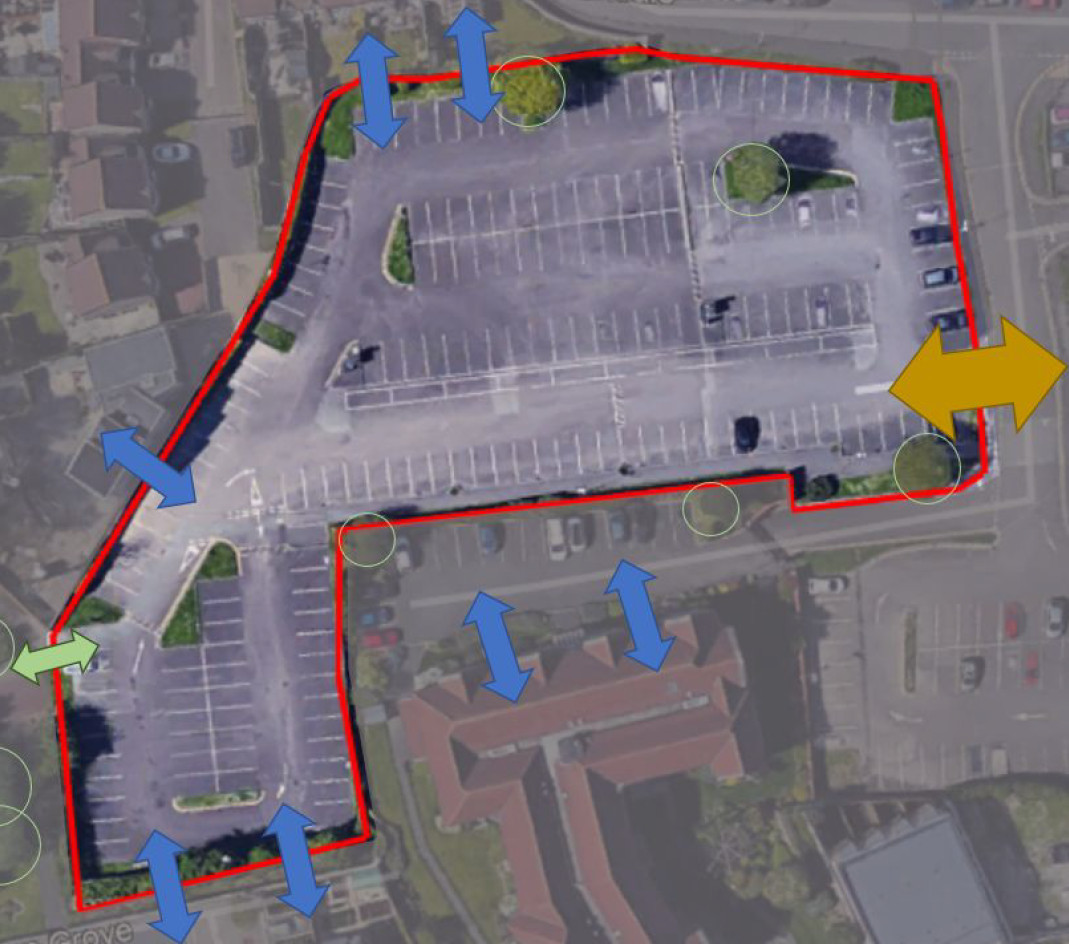
The site measures circa 0.5ha and enjoys c.35m frontage along Oxendale, from where vehicular access is gained. The site is currently in use as a public car park.
The boundary treatment is varied and fragmented; with the flat topography affording open views towards the new 3-storey Bluestone Court retirement living building (centre south) and the two-storey dwellings along Bullmead Close to the north-west. The eastern boundary is open to the car park, which is framed by a former solicitor’s office and residential properties. A pedestrian link at the south-east corner of the car park provides excellent pedestrian access to the town centre.
A pedestrian footpath to the west links the car park via landscaped green space to Couture Grove, one of the main boulevards serving the new Houndwood Estate which exhibits a contemporary design.
View from within the site western boundary looking north east
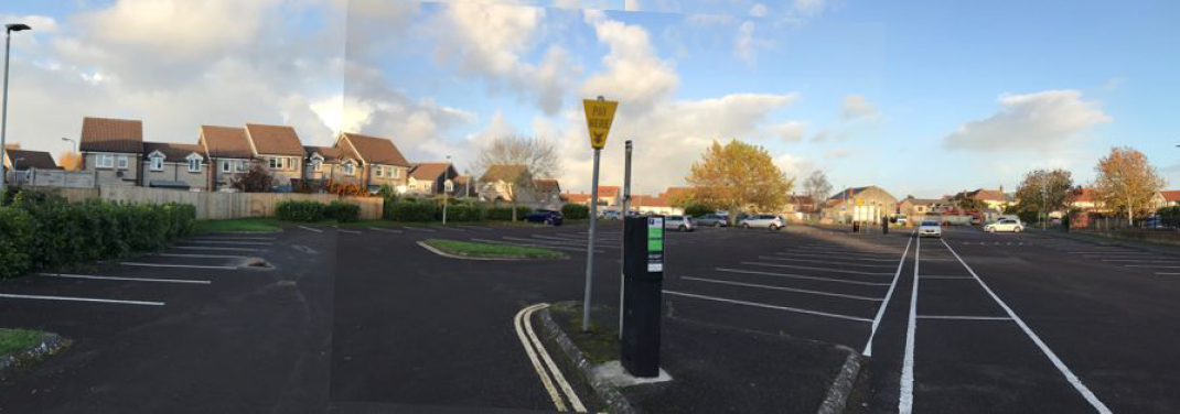
(Click to enlarge)


It is evident that:
Policy CP1 titles ‘Mendip Spatial Strategy’ explains:
‘The majority of development will be directed towards the five principal settlements of Frome, Glastonbury, Shepton Mallet, Street and Wells to reinforce their roles as market towns serving their wider rural catchments. Specific proposals for each place are set out in Core Policies 6-10. …’
It goes on to state:
‘In identifying land for development the Local Plan’s emphasis is on maximising the re-use of appropriate previously developed sites and other land within existing settlement limits as defined on the Policies Map’.
Core Policy 2 titled ‘Supporting the Provision of New Housing’ makes provision for 1,300 homes in Street, equivalent to 14% of the Districts overall needs. Core Policy 8 titled ‘Street Parish Strategy’ recognises that:
‘A high proportion of housing will arise from previously developed sites in a manner which respects and enhances the town’s character, …’.
The following technical assessments are underway:
Regrettably, due to the imposition of an increased annual housing target by Government, the Council is currently unable to demonstrate a 5-year Housing Land Supply. The latest position statement dated December 2019 estimates that the Council can only demonstrate a 3.8-year housing land supply. As such the tilted balance in favour of sustainable development is engaged.
Aster has worked with Mendip District Council to look at parking capacity within the town. There are 10 car parks in Street providing nearly 2,000 pay and display spaces. The Council monitored car parking capacity pre-covid for a continuous 5-month period. The daytime utilisation of Cranhill Road car park is typically less than 19% albeit this increases to around 25% in the peak period 9am-1pm. Nonetheless, this is far below the other car parks in Street. By comparison, during the morning peak (9am-1pm) the utilisation of Wilfrid Road is nearer 60%. Whilst Southside car park exhibits significant demand, there is latent capacity within the other car parks which are equally convenient for the town centre. It is important to stress that the proposals would retain 107 existing car parking spaces nearest the town centre, so would only entail a reduction in the overall number.
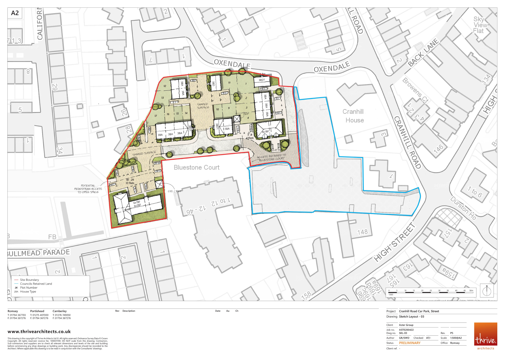
Aster is looking to bring forward a development of around twenty-nine new homes.
Mendip District Council have committed to work with Aster Homes to maximise the affordable housing delivery on this site. By working with an affordable housing provider from the outset there is scope to secure grant funding to maximise the affordable housing being provided over and above the Council’s policy targets. It is considered that this approach will best meet the objectives of both parties to deliver the much needed 100% affordable housing schemes.
An indicative layout plan has been prepared, albeit this might change following your feedback and as more information becomes available.
(Click to enlarge)
We will continue to update this webpage as the project moves forward, but now is the time to have your say and help shape the form and content of the planning application.
Should you have any questions or queries please do not hesitate to contact us via the comments page.
There will of course be a formal opportunity to make your views known to the Council once the application is registered sometime in the new year. It is envisaged that the application will be accompanied by:
Thank you for visiting our website. Your feedback is important to us so please provide comments using the tab in the title bar or contact us here:
For further information regarding this proposal, please contact Brett Spiller at Chapman Lily Planning on 01929 55 38 18.